Jacques-Cartier Park (Sherbrooke)
| Jacques-Cartier Park | |
|---|---|
 | |
Interactive map of Jacques-Cartier Park | |
| Location | Sherbrooke, Quebec, Canada |
| Coordinates | 45°23′42″N 71°54′33″W / 45.39500°N 71.90917°W |
| Created | 1930s |
| Operator | City of Sherbrooke |
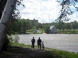
Jacques-Cartier Park is a park located in Sherbrooke, Quebec, along the shore of Lac des Nations.
History
Created in the 1930s by the clergy as part of the Œuvre des terrains de jeux (OTJ), the park was intended to supervise and organize recreational activities for children.[1]
By the mid-20th century, the site included two separate beaches for men and women, as well as facilities for regattas and canoeing.[1] In the 1960s, the adjacent body of water became an important location for water skiing.[1]
The park was officialised by the Commission on Toponomy of Quebec in 1989.[2] Now integrated into the Lac des Nations promenade network, Jacques-Cartier Park remains a central and heavily frequented green space in downtown Sherbrooke.
In 2024, the Sherbrooke City Council approved the construction of a pump track at Jacques-Cartier Park.[3] Construction began in July 2025.[4] The pump track was opened to the public on May 9, 2026 and is the longest pump track in all of Quebec.[5]
References
- 1 2 3 Quirion, René-Charles (2021-08-02). "L'histoire des espaces verts de Sherbrooke : au temps du zoo et de l'OTJ". Radio-Canada (in French). Retrieved 2026-05-19.
- ↑ "Parc Jacques-Cartier - Sherbrooke (Ville)". toponymie.gouv.qc.ca. Retrieved 2026-05-19.
- ↑ Deshaies, Thomas (2024-11-05). "Sherbrooke va de l'avant avec la « pumptrack » au parc Jacques-Cartier". Radio-Canada (in French). Retrieved 2026-05-19.
- ↑ "Pumptrack au parc Jacques-Cartier : les travaux sont commencés". City of Sherbrooke (in French). 2025-08-17. Retrieved 2026-05-19.
- ↑ Arel, Jean (2026-05-09). "La plus longue piste à rouleaux au Québec est ouverte à Sherbrooke". Radio-Canada (in French). Retrieved 2026-05-19.